


NEC Develops Advanced Disaster Assessment Tech Using LLMs and Image Analysis
TOKYO, Aug. 25, 2023 -- NEC Corporation has developed a technology for disaster damage assessment using a Large Language Models (LLMs) and image analysis. This technology enables users to immediately and accurately assess the extent and location of damage from the multitude of images collected when a disaster strikes. Going forward, NEC will contribute to the acceleration of evacuation guidance, rescue efforts, and other initial response activities in the event of a disaster by providing this technology to government ministries and municipal authorities in charge of disaster response.
 In recent years, the world has witnessed a rise in the frequency and severity of natural disasters, including intensified torrential rains and massive earthquakes. When disasters occur, it is vital to quickly and accurately assess the damage to expedite initial response activities such as evacuation guidance and rescue efforts for disaster victims. However, the realization of a rapid initial response remains a challenge because precipitation distribution maps and seismic intensity distribution maps, for example, as well as textual information received from residents, do not include sufficient details on the extent and location of damages. In contrast, images from disaster-stricken areas provided to municipalities and other entities (images captured by smartphones, drive recorders, CCTV, etc.) hold great promise as they contain extensive damage and geographical location information.
In an effort to accelerate initial response activities, NEC has developed a technology that can be used to quickly and accurately narrow down which images are necessary for assessing the impact of a disaster, and then display these images on a map with street address-level accuracy.
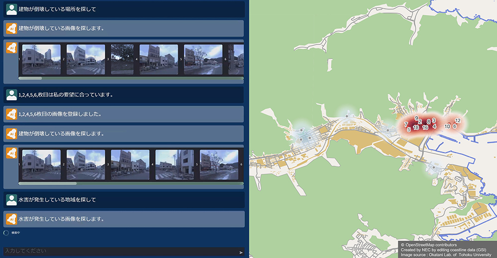
Figure 1: Results from narrowing down field images.
Features of the New Technology
Narrows down field images in accordance with a user’s intent
Images can be narrowed down from a multitude of field images to include only those aligned with a user’s intent by utilizing semantic interpretation of words of an LLM system and image analysis to determine image similarity.
Image recognition technology has conventionally been used for narrowing down images to those that are relevant for users. However, these technologies are only capable of recognizing images pre-trained, thereby limiting which images can be narrowed down. This has made it difficult to conduct surveys in accordance with a user’s intent, which varies depending on the type and scale of a disaster, the affected areas, and the extent of the situation.
This newly developed technology utilizes LLMs to narrow down field images using keywords. Moreover, employing image analysis and specifying the scene a user would like to search for makes it possible to narrow down scenes that are difficult to express in words. In other words, by combining LLMs and image analysis, users can accurately narrow down the images to only those matching their intentions, thereby making it possible to quickly respond to disasters as they unfold.
Displays the extent and location of damage on a map at street address level
In the case of field images for which the location of a disaster-stricken area is unknown, the location can be estimated with street address-level accuracy and then displayed on a map by comparing the images with aerial imagery and map data covering extensive areas.
Field images provided in emergency situations such as disasters do not necessarily include location information, which can sometimes make it difficult to identify disaster-stricken areas. While NEC has developed technologies for estimating locations through the utilization of satellite images and aerial photographs in the past, this latest technology has achieved the world’s highest matching accuracy, enabling location estimation with a high degree of precision, even for field images captured during a disaster.
To estimate locations, this technology automatically extracts areas such as roads, buildings, and traffic signals from field images and then matches them with map layout information (the shape and layout of roads, buildings, etc.). In this way, highly accurate estimation of a photographed location is made possible, even for images of partially collapsed buildings or partially flooded roads, by proactively using information on roads with a lower risk of damage in the event of an earthquake and information on buildings with a lower risk of submergence in the event of flooding to perform matching.
Future Plans
NEC plans to put this newly developed technology into practical use within FY2025 in an effort to help accelerate evacuation guidance, rescue efforts, and other initial response activities in the event of a disaster. In addition, NEC remains committed to making society safer, more secure, and more convenient by expanding the use of LLMs and image analysis technology to other applications.
About NEC Corporation
NEC Corporation has established itself as a leader in the integration of IT and network technologies while promoting the brand statement of “Orchestrating a brighter world.” NEC enables businesses and communities to adapt to rapid changes taking place in both society and the market as it provides for the social values of safety, security, fairness and efficiency to promote a more sustainable world where everyone has the chance to reach their full potential. For more information, visit NEC at https://www.nec.com.
Source: NEC


